Bridges

Going through ALPR data, I noticed how some ALPR cameras were not positioned in typical areas or near the intersection of roads. Rather, these were installed at the intersection of roads and rivers. These bridges represent chokepoints in the road network that are unavoidable. For example, South of the Ohio river there are only 18 crossings (excluding ferries) along the Mississippi river wikipedia page. That is an area of ~800km / ~500miles. Thus, to observe all interstate traffic would use a trivial number of cameras. The same vulnerability exists on smaller rivers as well.
There is also the aspect that rivers tend to delineate the municipal boundaries. Municipalities/states will tend to place ALPRs around their perimeter. Although not a deliberate effort to monitor these “chokepoints”, the end result is the same.

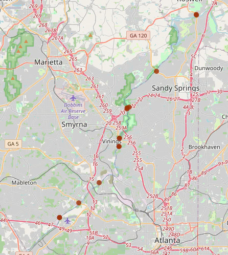
Example:

Most of the ALPRs in the example above are on one side of the river. Thus, the county on the left is likely putting ALPRs all around the perimeter of the county.


What are Typical areas? (with overpass turbo queries):
In vicinity of ramps of large roads
nwr[highway=primary_link]({{bbox}});
nwr[highway=secondary_link]({{bbox}});
nwr[highway=motorway_link]({{bbox}});

Hospitals
nwr[amenity=hospital]({{bbox}});
nwr[healthcare=hospital]({{bbox}});

Parks
nwr[leisure=park]({{bbox}});

Shopping Malls
nwr[shop=mall]({{bbox}});

Sports Pitch
nwr[leisure=pitch]({{bbox}});

Warehouses
Police Departments / Correctional Facility
Lowes/Home Depot
Higher density housing (HOA areas/new builds)


The following ALPRs were detected within 100 meters of a bridge that crossed over a river.

Code
import pandas as pd
import geopandas as gpd
import folium
import itables
from datetime import datetime
from folium.plugins import MarkerCluster

m = folium.Map([35, -100], zoom_start=4)

bridgegdf = gpd.read_file("../../../osmetc/bridges.gpkg")
bridgegdf = bridgegdf.drop(["man_made", "river_waterway"], axis=1).rename({"alpr_osmid":"ALPR ID","alpr_highway":"ALPR highway","camdir":"Direction 1","camdir2":"Direction 2","road_osmid":"Road ID","road_name":"Road Name","road_highway":"Road Type","river_osmid":"River ID","river_name":"River Name"}, axis=1)

marker_cluster = MarkerCluster(disableClusteringAtZoom=10).add_to(m)

for idx, row in bridgegdf.iterrows():
    popup_html = f"<style> th\
                {{border:1px solid black;\}}</style>\
                <table><tr>\
                    <th>Road: </th>\
                    <th>{row['Road Name']}</th>\
                </tr><tr>\
                    <th>Road Type: </th>\
                    <th>{row['Road Type']}</th>\
                </tr><tr>\
                    <th>ALPR ID: </th>\
                    <th>{row['ALPR ID']}</th>\
                </tr><tr>\
                    <th>Road ID: </th>\
                    <th>{row['Road ID']}</th>\
                </tr><tr>\
                    <th>River ID: </th>\
                    <th>{row['River ID']}</th>\
                </tr><tr>\
                    <th text-align='center' colspan='2'><a href='https://www.openstreetmap.org/node/{row['ALPR ID']}' target='_blank'>https://www.openstreetmap.org/node/{row['ALPR ID']}</a></th>\
                </tr></table>"
    folium.Circle(
        location=[row.geometry.y, row.geometry.x], 
        popup=popup_html, fill=True, radius=20, weight=9,color="#9E2F02",opacity=0.8,fillOpacity=0.5
    ).add_to(marker_cluster)

m
<string>:17: SyntaxWarning: "\}" is an invalid escape sequence. Such sequences will not work in the future. Did you mean "\\}"? A raw string is also an option.
<>:17: SyntaxWarning: "\}" is an invalid escape sequence. Such sequences will not work in the future. Did you mean "\\}"? A raw string is also an option.
<string>:17: SyntaxWarning: "\}" is an invalid escape sequence. Such sequences will not work in the future. Did you mean "\\}"? A raw string is also an option.
<>:17: SyntaxWarning: "\}" is an invalid escape sequence. Such sequences will not work in the future. Did you mean "\\}"? A raw string is also an option.
/tmp/ipykernel_438935/1471398686.py:17: SyntaxWarning: "\}" is an invalid escape sequence. Such sequences will not work in the future. Did you mean "\\}"? A raw string is also an option.
  {{border:1px solid black;\}}</style>\
<string>:17: SyntaxWarning: "\}" is an invalid escape sequence. Such sequences will not work in the future. Did you mean "\\}"? A raw string is also an option.
Make this Notebook Trusted to load map: File -> Trust Notebook
Code
itables.show(pd.DataFrame(bridgegdf.drop(["geometry"], axis=1)), maxBytes=200000, allow_html=True)
ALPR ID ALPR highway Direction 1 Direction 2 Road ID Road Name Road Type River ID River Name url
13461160002NaN175NaN10766671411th Streetprimary766536158Kishwaukee Riverhttps://www.openstreetmap.org/node/107666714
12463240809NaN0NaN203503870120th Avenueprimary135591280Macatawa Riverhttps://www.openstreetmap.org/node/203503870
12474351315NaN160NaN203503870120th Avenueprimary135591280Macatawa Riverhttps://www.openstreetmap.org/node/203503870
13695559201NaN37NaN13635451612600 Southprimary1422835174Jordan Riverhttps://www.openstreetmap.org/node/136354516
13672847501NaN265NaN5634625126th Streetprimary319533454Hudson Riverhttps://www.openstreetmap.org/node/5634625
12639395803NaN145NaN12777522112th Avenuesecondary1494843949Rock Riverhttps://www.openstreetmap.org/node/127775221
13479789302NaN0NaN945248213th Streetprimary585253806Savannah Riverhttps://www.openstreetmap.org/node/9452482
13346618901NaN99NaN7107065615th Avenuesecondary1500117248Rock Riverhttps://www.openstreetmap.org/node/71070656
13346618201NaN270NaN7107065615th Avenuesecondary1500117248Rock Riverhttps://www.openstreetmap.org/node/71070656
13346617901NaN102NaN7107065615th Avenuesecondary1500117248Rock Riverhttps://www.openstreetmap.org/node/71070656
(1,565 more rows not shown)
NoteRoad name is missing?

Some bridges lack the “name” tag that is available in other bridges/roads. However, YOU can help correct the OpenStreetMap data by copying over the tag from the other segments of the road.